GEOSPATIAL MODELLING FOR PUBLIC HEALTH APPLICATIONS
The Geospatial Modelling Workshop is an intensive training programme for statisticians and public health professionals looking to build their skills in geospatial analysis and modelling. Drawing on real-life examples from malaria research, the programme guides participants from foundational spatial data concepts through to Bayesian geostatistical modelling equipping them with skills they can continue to build on long after the training ends.
The workshop is run annually, bringing together leading researchers and practitioners from across the region.
2
Cohorts Delivered
400+
Applicants to Date
~30
Selected per Cohort (avg)
7+
Countries Represented
Who is MAP?
WHO Collaborating Centre in Geospatial Disease Modelling
MAP is a designated World Health Organization Collaborating Centre in Geospatial Disease Modelling. Through this partnership, we provide modelling and analysis directly to the WHO Global Malaria Programme, and via WHO, to individual countries. Our estimates are cited in the WHO World Malaria Report and the Global Burden of Disease study, which MAP has contributed to since 2016 in partnership with IHME.
This training programme is taught by the same scientists producing that work. You’ll learn the methods MAP uses to inform global and national malaria policy.
From Data to Decisions
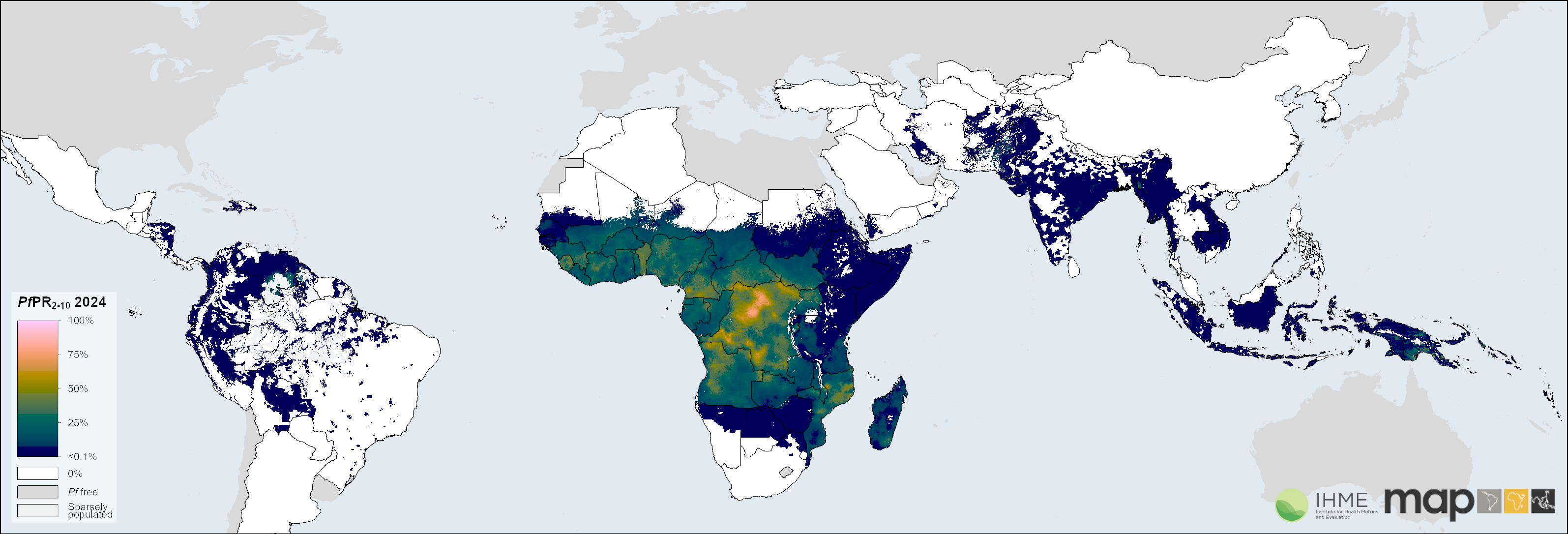
Source: Weiss et al. (2025). Mapping the global prevalence, incidence, and mortality of Plasmodium falciparum and Plasmodium vivax malaria, 2000-22: a spatial and temporal modelling study. The Lancet. Estimates form part of the Global Burden of Disease (GBD) 2025 study.
Every cohort works with malaria and real-world data, using the same Bayesian geostatistical methods taught in the programme to produce modelled risk surfaces like the one shown here — moving from raw spatial data to maps that inform decisions.
What You’ll Gain
Expert-Led Training
Hands-on training in advanced statistical models, taught by leading experts in geospatial modelling and public health.
Modern Methods
Learn current geospatial modelling methods — including Bayesian geostatistical approaches (e.g. INLA, INLAbru) — from practitioners actively using them in real malaria and public health research.
Real-World Data
Work with the same spatial and real-world datasets MAP uses to produce WHO’s global malaria estimates — moving from raw data to models that inform decisions.
Regional Network
Join a growing regional network of geospatial modellers across Sub-Saharan Africa.
Certification
Certificate of completion awarded to all participants.
Career Impact
Alumni have gone on to apply these methods in their own research, publishing manuscripts and papers building on skills learned in the programme.
Ready to Apply?
Review the eligibility criteria and application details on the Call for Applications page.
Applications close 30 August 2026 — apply now.
In Partnership With